


The Economic Development team at the Urban Unit works towards making regions, areas, and cities competitive and thriving with economic activity while providing for improved quality of life through healthcare and education.
The team focuses on the impacts of spatial agglomeration, manifesting local competitive advantages and defining future opportunities for local economic development based on local endowments. We also provide urban economic analysis, economic modelling, demographic analysis, strategic planning, cost-benefit analysis, economic impact analysis, cluster analysis, and strategic land use planning.

Main aspect of this activity is survey of economic establishments and creation of a centralized data repository for SMEDA so it can analyze its data and make informed decision. The objective is to gather data on economic entities. The survey aims to maximize coverage by reaching out to a wide range of economic entities across different sectors (Manufacturing, services, IT, wholesale and trade) and geographic locations.
To ensure that the enumerators visit each place in the study area, the built-up area were extracted from the satellite imagery using image analysis. One the built-up area is extracted from the satellite image; it was used to develop Enumerator survey boundaries.
A mobile based application developed for the purpose of field data collection and data entry. All the collected information was synched with the main database and monitored through a monitoring system which helped in finding the progress of each enumerator. The survey progress monitoring system was conducted by web-based dashboard which displayed all the progress related to data collection in the field.
The collected data is being integrated with already available data sets and will be shared with relevant stakeholders after proper cleaning, quality control checks, validation, and proper coding of the variables.
Client: SMEDA

Household surveys serve as the primary sources for indicators related to living conditions, poverty, and social exclusion along with offering detailed information on various well-being indicators. Sample sizes are often too small to be representative of smaller sub-national units and these do not cover all areas. Census data provides complete coverage enables assessments for small areas, though details on poverty and social exclusion are limited. To improve this, we need to combine data and use small area estimation techniques to delve deeper into data.
This involves working with national statistical agencies and using official data to estimate poverty risk in the smallest regions of Punjab. Area-level models, like Fay-Herriot, are quite useful when census microdata is not available, though improvements in precision may be limited. When census microdata is accessible and the data from surveys and censuses are comparable, unit-level methods are likely to produce the highest quality estimates.
The scope of project includes;
iii. This precision helps in allocating resources efficiently and in designing policies that directly address the needs of the poorest regions.
The objective is to produce reliable and accurate poverty estimates that can guide targeted policy interventions and resource allocation. Integration of data from national censuses to provide demographic and socio-economic characteristics that will serve as auxiliary information for the estimation process. Additionally, incorporation of relevant administrative records, such as welfare program data, employment records, and tax data, will complement and enhance the survey data.
The collected data shall be validated and cleaned to address issues such as missing values, outliers, and inconsistencies. Imputation methods will be applied as necessary to handle missing data and survey, census, and administrative data will be merged to create a comprehensive dataset. Compatibility across data sources will be ensured through standardization and normalization.
Direct estimation methods to calculate preliminary poverty rates and indicators directly from the survey data for each small area, will be carried out. Regression-based models will be employed to estimate poverty using auxiliary variables from census and administrative data. These models will help address limitations in direct survey data by leveraging additional information. Application of hierarchical models to account for variability at multiple levels (e.g., individual, household, small area). Hierarchical Bayesian models will be particularly useful for integrating both survey and auxiliary data.
Empirical Best Linear Unbiased Prediction (EBLUP) methods will be utilized to refine poverty estimates by combining survey data with auxiliary data, providing unbiased and efficient estimates for small areas. Spatial econometric models will be incorporated to account for spatial dependencies and correlations in poverty data, improving the accuracy of the estimates.
Cross-validation to evaluate the accuracy of the models is to be done. The estimates will be compared with known benchmarks or external data to assess their performance. Sensitivity analysis will be conducted to examine the impact of different model assumptions and parameter choices on the estimates, helping to understand the robustness of results.
Poverty maps will be developed to visually represent distribution of poverty across small areas. These maps will highlight areas with varying poverty levels and identify patterns. Based on the estimated poverty levels, teams will identify priority areas for targeted policy interventions and recommend actions according to the spatial distribution and severity of poverty. A detailed technical report will be prepared to describe the methodology, data sources, model results, and validation procedures. This report will include clear explanations of the estimation process and findings. Results sharing through academic publications, policy briefs, and presentations at relevant conferences. Engagement with stakeholders and policymakers will ensure the findings are effectively utilized.
Client: P&D Board

Optical imagery utilizes visible and near-infrared light captured by satellite sensors will create high-resolution images of Earth's surface. The high spatial resolution of optical imagery allows for detailed monitoring of infrastructure development, including construction of new roads, buildings, and other facilities. By regularly capturing images over time, it is possible to track and quantify these changes, providing valuable insights into the patterns and pace of urbanization and development.
The scope of project includes;
iii. This evidence-based approach supports more effective planning and implementation of road projects, maximizing their developmental impact.
Satellite data allows for continuous monitoring over time, making it possible to analyze the long-term impacts of road development on economic growth, land use changes, and population dynamics.
Methodology for this activity will involve several key steps. Road network data from government agencies or open data sources, including details on road construction dates and types, shall be collected. Night light data will be sourced from satellite platforms such as the Defense Meteorological Satellite Program (DMSP) or the Visible Infrared Imaging Radiometer Suite (VIIRS). In addition, we will gather economic and poverty-related data from various databases and surveys for comparative analysis, as well as development indicators like employment rates and social indicators from relevant government reports, surveys, and datasets.
In the statistical analysis phase, application of change detection algorithms to identify differences in road infrastructure over time. Techniques such as image differencing and machine learning models for classification will be used. Conducting of spatial analysis to correlate changes in road infrastructure with development indicators through satellite-based data, utilizing buffer and overlay analysis, as well as spatial regression models.
To validate findings, a comparison to be made with ground data and other established measures of economic activity and poverty to ensure the accuracy and reliability of the night light data as a proxy. Finally, a comprehensive report and visualization, including maps, charts, and summaries will be developed for effective communication of the results to stakeholders and policymakers.
Client: P&D Board

Climate-Smart Agriculture (CSA) is an approach to agricultural development that aims to address the intertwined challenges of food security and climate change (Lipper et al., 2014). CSA targets three objectives: (i) sustainably increasing agricultural productivity to support equitable increases in farm incomes, food security, and development; (ii) adapting and building resilience of food systems to climate change; and (iii), where possible, reducing greenhouse (GHG) emissions from agriculture (FAO, 2013). Whether a technology is CSA is based on its impact on these outcomes and agricultural interventions that meet these goals are considered “climate-smart” (FAO, 2013). Interventions ranging from climate information services to field management have potential to achieve these goals (Nyasimi et al., 2017).
Punjab, the agricultural heartland of Pakistan, is increasingly vulnerable to adverse impacts of climate change. Rising temperatures, unpredictable rainfall patterns, and extreme weather events threaten agricultural productivity, food security, and livelihoods of millions of farmers.
Climate Smart Agriculture (CSA) is of paramount significance in mitigating the adverse effects of climate change on agriculture. CSA integrates practices and technologies that not only increase agricultural productivity but also enhance resilience to climate impacts and reduce greenhouse gas emissions. By adopting CSA, farmers can achieve sustainable crop yields, improve soil health, and manage water resources more efficiently. Furthermore, CSA promotes diversified farming systems, which can buffer against climate shocks and provide economic stability for farming communities. In essence, CSA represents a holistic approach to transforming and reorienting agricultural systems to support food security under the new realities of climate change.
This project aims to develop a comprehensive CSA plan by conducting a thorough study to identify and analyze specific climate change threats, impacts, and farmer awareness and adaptation to CSA practices and technologies. By understanding these threats in detail, targeted strategies can be developed to enhance the adaptability of farmers and agricultural systems. Additionally, the project will identify gaps in current practices and policies, propose innovative solutions, and plan future interventions that are both practical and scalable.
This project aims to investigate the barriers to CSAPs adoption and develop strategies to improve dissemination and understanding of these technologies among smallholder farmers, thereby contributing to increased resilience, food security, and sustainable agricultural development.
Before designing and implementing any CSA project, it is crucial to conduct evaluation based on several key factors. This initial assessment will ensure that CSA technologies and practices are effectively tailored to the needs of farmers and achieve the desired impact. The following components need to be studied for successful deployment of CSA technologies:
Client: P&D Board

Poverty in Punjab is a complex issue requiring multi-faceted approaches for effective alleviation. While significant progress has been made, ongoing efforts to address income disparities, improve access to education and healthcare, and enhance social protection mechanisms are crucial for sustainable poverty reduction. A well-structured socio-economic registry is essential for effective policy-making and the implementation of targeted social programs. By capturing detailed and accurate information across various dimensions, it helps governments and organizations to address socio-economic challenges more efficiently and equitably. Taking steps in the said direction, Government of the Punjab is developing Punjab Socio-Economic Registry (PSER). PSER is expected to be a comprehensive database that collects, stores, and manages detailed information about individuals and households. This registry shall be used for targeting social programs, poverty alleviation initiatives, and policy planning.
The scope of Field Verification Survey by Urban Unit under the PSER includes the following key activities;
Client: P&D Board, Punjab
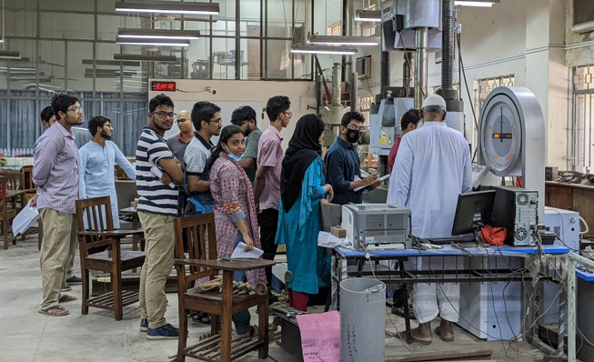
The Material Testing Lab project is designed to meet critical objectives that will strengthen Punjab’s industrial base, with a strong focus on enhancing product certification, improving market access, and increasing exports. These objectives align with the Punjab Growth Strategy, which emphasizes industrial growth and export-led economic development.
The primary goal of this project is to streamline the certification of products, ensuring that local manufacturers — particularly in key sectors like sports goods and surgical instruments — can meet stringent international safety and quality standards. By offering state-of-the-art testing and certification processes, the lab will enable industries to obtain the necessary certifications for exporting to high-value markets such as the EU, US, and Middle East. This addresses a critical gap in local infrastructure and supports Punjab’s goal of positioning itself as a global export hub.
A central objective of the project is to improve market access for local manufacturers, especially small and medium enterprises (SMEs). The labs will provide affordable and accessible testing services that help SMEs meet global compliance requirements. This is directly linked to the Punjab Growth Strategy's aim of promoting industrial expansion by removing barriers to international market entry. By offering these services locally, the project reduces the reliance on costly foreign testing facilities, making it easier and faster for businesses to access international markets, thereby supporting their growth and integration into global supply chains.
Furthermore, the project is positioned to drive enhanced export performance by ensuring that products from Punjab meet international standards, which is essential for maintaining and expanding the region’s export capacity. This directly supports Punjab's strategic goal of increasing its global export share, as outlined in the Punjab Growth Strategy. With globally recognized certifications, local products will be more competitive in the international market, helping to elevate the region’s export profile.
The current project marks a significant step forward in addressing this gap by proposing the establishment of two specialized material testing laboratories. One laboratory will be established in Sambrial, Sialkot, specifically catering to the surgical instruments industry, while the other will be located at the UET Kala Shah Kaku campus to serve the electric home appliances industry. These facilities aim to provide targeted support to local industries in Gujranwala and Sialkot by enhancing their product quality and ensuring compliance with international standards. This initiative, led by Urban Unit, will play a pivotal role in expanding the export potential of these sectors by offering affordable and advanced testing capabilities. Through these dedicated laboratories, businesses will be better equipped to meet global requirements and enhance their competitiveness in international markets.
Client: ICI&SD Department
There is a multitude of literature that is indicative of the gap between the labour supply and demand. However, little has been done to understand the needs of the modern labour force. TEVTA is the prime institution of the Government of Punjab, that focuses on skill development and training. It is thus important for TEVTA to understand the current demands of Punjab’s labour force, and deploy the relevant skill set to Punjab’s work force. In order to assess the demands of Punjab’s work force, a multi-faceted approach is being deployed to build a profile of its workforce. The Urban Unit conducted a sectoral and spatial analysis; to classify the needs of each sector of the economy at the district level.
This will be the first time that a detailed study will be carried out to understand the current skill development needs of the labour force. By mapping out the skill demands of each trade and occupation at district level, this activity will not only enhance labour force productivity and employability in each sector of the economy but will also allow each region to develop its own competitive advantage, once the skill sectors are spatially aligned.
The scope of study includes examining the current issues of labour force in Punjab and to understand their needs for skill development and capacity building by conducting multiple levels of analysis. The study maps out demands of skilled labour force at each occupation and trade level, for each district of the province. Further, it projects (10 years) to understand the future demands of Punjab’s skilled labour force in different sector of industries, occupations and trades. In future FGDs are being conducted and sampling being done to further strengthen the data sets.
Client: TEVTA

Government of the Punjab developed the Punjab Jobs & Competitiveness Program for Results (J&C Program) with the assistance of World Bank to support industrial and spatial development in Punjab. Punjab Spatial Strategy Project (PSS) is one of the key components of the J&C Program. Planning and Development Board, Government of the Punjab, (P&D Board) was the Sponsoring Agency and Urban Sector Planning and Management Services Unit (Pvt) Limited (the Urban Unit) was the Executing Agency for the PSS Project.
The Strategy developed under the PSS Project is manifestation of the overall spatial vision, polices and future spatial development objectives for Punjab. The Punjab Spatial Strategy assesses the potential of Punjab’s growth corridors and growth nodes and prioritizes and coordinates investments in the province. This strategy will inform in particular public investments related to connectivity, infrastructure, urbanization and development of industrial zones, which will be reflected in the MDTF (Medium-Term Development Framework – a multi-year indicative budget) before approval through the ADP (Annual Development Plan – the annual budget) process.
Client: Planning and Development Department

Conceptually, Local Economic Development (LED) is territorial in nature. LED practitioners look at the city as a compact entity with economic tentacles spread through the metropolitan regions and beyond. Internationally, land use and its development have a pivotal role in the holistic LED planning. Keeping in view the role of local government (municipalities) in LED, the Urban Unit intends to build the capacity of the local governments in developing their indigenous Economic Development Strategy at the city level (municipal corporations) in Punjab.
In this regard, in January 2020, UNDP contacted the Urban Unit to prepare an Economic Development Strategy (EDS) for Faisalabad. In March 2020, after extensive secondary research and consultative sessions with the relevant local stakeholders in Faisalabad, the Urban Unit prepared the EDS Report. Based on research and consultation input, a city economic vision and 12 Local Economic Development (LED) initiatives were also proposed for the economic betterment of Faisalabad.
These Twelve LED initiatives were proposed with each having its own set of outcomes and measurements. This practical orientation of the initiatives will have a direct influence on the individual economic sectors of the city. These initiatives have the requisite agility to serve the safety parameters, as envisaged under the coronavirus pandemic. The autonomous nature of LED will enable cities to utilize their economic circuit breaker against the national pandemic crisis.
Client: United Nations Development Programme

In Punjab, the Urban Sector Planning and Services Management Unit (on behalf of the Deutsche Gesellschaft für Internationale Zusammenarbeit (GIZ) Pakistan and PSPA) undertook the data collection and research exercise for the assessment of selected social protection in Punjab ISPA CODI framework. A total of six social protection programmes at both federal and provincial level were chosen for this assessment in consultation with the PSPA;
Three districts, Lahore, Rahim Yar Khan, and Sargodha were selected to observe the implementation of programmes at the local level. The project was a huge success of the Urban Unit as it completed the project within the stipulated time-frame and limited budget.
The Urban Unit team visited the three districts and conducted qualitative research. The Key Informant Interview (KII) and Focus Group Discussions (FGD) were employed as the primary research tool, as suggested in CODI by ISPA.
The comprehensive report with findings and recommendations will soon be released by the GIZ Pakistan which will help evaluate, benchmark and upscale the performance and redesigning of the social protection system in Punjab, in particular, and in Pakistan, in general.
Client: The Deutsche Gesellschaft für Internationale Zusammenarbeit (GIZ) GmbH

Punjab Planning & Policy Support Program (P3SP).
The programme is aimed at supporting P&D Board in evidence-based decision making and policy planning. The Urban Unit will be supporting P&D Board in updating existing spatial data, performing evidence-based area planning and capacity building of Departments to support in achieving the objectives of Punjab Growth Strategy 2023 and Punjab Spatial Strategy 2047. The Urban Unit has data repository comprising of a variety of GIS layers and digitized socio-economic data sets. The data can be utilized to enhance analytical lens of Government of the Punjab in planning and policy making processes.
The program has three key components: :
1. Spatial Decision Support System
2. Area Planning Support
3. Capacity Building
The programme will support data access and dissemination to all tiers of government for planning, policy and development support. The programme will ensure expansion of Spatial Decision Support Systems in middle and lower tiers of government / local governments. Developing & deepening the existing Spatial Decision Support Systems, to be undertaken in terms of their underlying data sets and decisions coverage in the same sectors. It will support in developing area plans using the extensive data available in the Urban Unit. Strong capacity strengthening programme for training departments and agencies will be conducted on how to use modern tools and systems for informed and evidence-based planning and decision making.
The Key deliverables of the Project are:
1 Deepening of existing Spatial Decision Support Systems
2 Developing new Spatial Decision Support Systems
3 Support in development of area planning
4 Support to departments & local governments in data, mapping & technical support
5 Capacity building of departments and agencies
Client: P&D Board, Punjab