


Effective city administration relies heavily on robust planning which, in turn, is contingent upon the availability of accurate and dependable data. Geographical Information System (GIS), Remote Sensing and Surveys have evolved into sophisticated computer- based systems adept at integrating data from diverse sources to provide essential information for decision-making in urban planning and land management.
Our cutting-edge spatial data analysis platform harnesses the power of artificial intelligence (AI), machine learning (ML), and cloud computing (CC) to unlock hidden insights from geographic information. By integrating satellite imagery, surveys and crowd-sourced data, our platform utilizes cloud-based processing to analyze vast spatial datasets, identifying patterns and trends that inform smarter decision-making. Advanced ML algorithms, such as convolution neural networks (CNNs) and generative transformers, enable precise object detection, land use classification, and predictive modeling. With real-time data visualization and spatial data infrastructure, we empower urban planners, policymakers, and stakeholders to make data-driven decisions, driving sustainable development, efficient resource allocation, and resilient infrastructure planning.
Jointly to be done by Pakistan Civil Aviation Authority (CAA) and the Urban Unit, it marks a transformative step in digital land management, harnessing GIS, remote sensing, and surveying technology to establish a comprehensive cadastral mapping system. Spanning some 52 strategic CAA sites across Pakistan, this project is all set to digitize 26,000 acres of land. By converting manual land records into an integrated, user-friendly digital repository, this project will fortify land governance, enhance operational efficiency, and empower the CAA in safeguarding its critical assets.
Client: Pakistan Civil Aviation Authority (CAA)

This project leverages Geographic Information Systems (GIS) to enhance tourism planning and development in Punjab, integrating georeferenced data into dynamic digital maps. By compiling a spatial database of 100 archaeological and heritage sites, the initiative aims to classify and analyze these locations based on accessibility and historical significance. Detailed site plans for 20 selected destinations will provide a comprehensive view of transportation, accommodation, and recreational options available to travelers. The project will culminate in an ATLAS of Sites, featuring rich visualizations and essential information to support a modern, accessible tourism experience in Punjab.
Client: Tourism, Archaeology and Museums Department, Govt. of the Punjab.
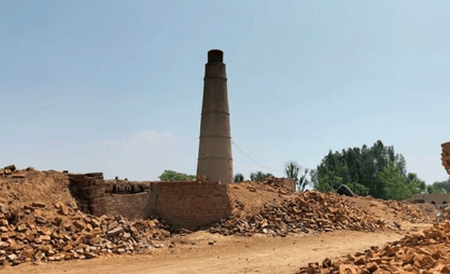
This project aims to address environmental as well as health problems caused by brick kilns in Punjab. Brick kilns are important for the local economy, but they also create a lot of air pollution. The project will map the locations and technologies of kilns to collect important data. This data will help the Environmental Protection Agency (EPA) better manage the brick kiln industry. The focus is on finding high-risk areas, encouraging cleaner technologies, and protecting the environment while supporting workers’ livelihoods. By collecting and analyzing data, the project aims to improve air quality, public health, and sustainable practices in Punjab’s brick kiln sector.
Client: Environmental Protection Agency (EPA)

In partnership with the Punjab Cooperative Board for Liquidation (PCBL), this project aims to digitize land management through digital mapping and open-source satellite data processing across Punjab. By compiling, geo-referencing, digitizing Mauza maps and Mussavies, and linking revenue records to precise land parcels, this initiative will create a consolidated, interactive database of PCBL’s assets. Enhanced with geo-tagged features and accessible through a user-friendly dashboard, this system empowers PCBL with efficient decision-making tools, comprehensive land insights, and essential training for sustainable database management.
Client: Punjab Cooperative Board for Liquidation (PCBL)

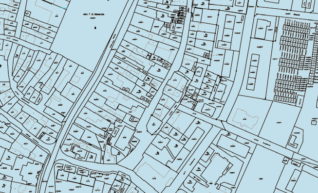
The Urban Immovable Property Taxation (UIPT) System introduced in Punjab has been a stepping stone in modernizing property tax administration systems in the country. Being the first of its kind, the project focused on improving the coverage ratio using a combination of satellite imagery and aerial photographs along with mass field-based data collection. This GIS-based computerization system incorporates information flow processes to improve transparent management for better oversight and monitoring of tax base coverage, assessment, revenue collection and strategic analysis. The modernization of the UIPT also involved broadening the tax base and moving from manual processes to automated systems. The GIS-IUIPT not only resulted in increased revenue collections, but also accurate identification of properties, standardized calculation of the assessed value, and higher taxpayer confidence in the property tax administration system. This particular project proved instrumental in not only revolutionizing the Excise and Taxation Department but also encouraged the others to join this bandwagon of moving towards a digital economy.
Since the introduction of this system, collection of the province’s taxes has improved significantly. Property tax base has witnessed an unprecedented increase of 150%, which has led to a record collection of 1.9 billion rupees. In addition, the automation of the property tax administration system not only enabled the expansion of the tax base but also added half a million new units to the UIPT. Following the successful implementation of this project in Punjab, this revolutionary reform system is now being scaled up throughout the country. With KP and Sindh devoting their efforts to implement this system to improve their tax cadastre.
Client: ET&NC Punjab, ET&NC KP, ET&NC Sindh

Pakistan Railways entered into a contract
agreement with the Urban Unit on March 16th 2015 to embark upon the
task of GIS based Land Management System of lands of Pakistan Railways. The
project titled “Asset management of Pakistan Railways Land by GIS based
computerization and Development of database software for MIS”, of Pakistan
Railways Land, is a vision of the present leadership to use technology for
effective and efficient management of one of the most important asset i.e. land
- economic corridor for the organization.
The current project is independently been
acclaimed by various entities as one of the most successful automation projects
completed over a period of last two years. The Standing Committee of Senate and
Asian Development Bank has appreciated the system developed jointly by Pakistan
Railways and Urban Unit.
Now the teams of the Urban Unit and Pakistan
Railways are making deliberations for implementation of system to all the hierarchical
levels of Directorate of Property & Lands. For this purpose the Urban Unit
shall enter into a Service Level Agreement with Pakistan Railways to provide
technical and human resource support for automation of process flow in
accordance with institutional settings of Pakistan Railways Land Management
System. Hence, this system is anticipated to become Decision Support System for
the land management of Pakistan Railways. The system may prove a new economic
corridor for Pakistan Railways.
Client: Pakistan Railways

The
Urban Unit provided technical support to Punjab Industrial Estates Development
and Management Company (PIEDMC) to geo-tag each building in Sundar Industrial
Estates (SIE).
The
Urban Unit converted all master plans into GIS data formats, developed android
based survey application, conducted surveys along with PIEDMC officials and
designed a real-time geo-portal for visualization with query based mapping
solutions.
Scope of Work
Following
tasks were performed for geo-tagging of industries in Sunder Industrial Estate:
·
Collection
of primary data and CAD drawings of Sundar Industrial Estate
·
Satellite
Image collection for each industry
·
Integration
of CAD drawings and data joining
·
Android
applications development as per requirement
·
Survey
of Sundar Industrial Estate
·
Web
portal development and data visualization
Client: Punjab Industrial Estate